Wayfinding in the natural environment
Navigation from place to place is a fundamental human activity and an integral part of everyday life.
Navigation from place to place is a fundamental human activity and an integral part of everyday life. Where am I? Where am I heading? What is my quickest route?
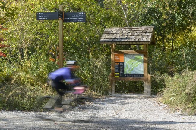
Wayfinding can be defined as all of the ways in which people interpret their surroundings to orient and navigate a physical space. It is a holistic concept with a focus on making all parts of the landscape easy to read and understand. In its conventional sense, Wayfinding includes elements such as physical signs, digital information, maps, landmarks or the landscape itself.
Effective wayfinding addresses three key human behavioural needs:
- Don’t make me think - Create a comprehensive, clear and consistent visual communication system with concise messaging
- Only tell me what I need to know - Show information relevant to the space, location and /or pathway
- Remove clutter - avoid unnecessary detail or physical clutter to create a clear environment
So how does this apply to your local park? People go to parks for a break from the rigors of everyday life and to get a break from the information overload of the city but even in a natural environment, the basics of a wayfinding system are still required: consistent identification, orientation and navigation.
There are three key elements needed to create a successful wayfinding system for the natural environment:
1. Link to/from areas beyond the park boundaries – parks, trails and green spaces should not be considered as separate entities but as part of the city’s wider offer
2. Get the basics in place – although park wayfinding may be less about the shortest route from A-B the basic principles of wayfinding still apply
3. Promote a positive experience – whether you’re playing sport, going for a jog or just taking some time out wayfinding in the natural environment should be seen but not heard!

An example of this good practise is the city of Toronto in Canada. With more than 1,600 public parks and 600 km of trails, Toronto’s parks network covers a substantial 13% of the City’s land area and is one of its greatest assets - essential to improving residents’ quality of life.
The City of Toronto’s Parks, Forestry & Recreation team appointed Steer Davies Gleave to deliver an ambitious project aimed at improving wayfinding across the City’s parklands. The project aims to implement a unified wayfinding system for parks and trails to:
- Provide consistent identification, orientation and navigation in and around parks and trails
- Encourage visiting, exploring and appreciation of Toronto’s natural assets
- Serve all park and trail users regardless of their abilities
- Reduce clutter and redundant infrastructure on parks and trails, thereby enhancing the natural environment
- Be economically sustainable and viable in the long term
Extensive site visits and observations identified a number of challenges in Toronto’s current parks and trails wayfinding, among them: attractiveness of wayfinding products, legibility of information, physical clutter and repetition, information overload or a lack of information at key gateways, poor accessibility, and inconsistent naming and information hierarchy.
These challenges aren’t unique to Toronto and can all too often be seen all over the world!
The Toronto Parks & Trails Wayfinding project is being undertaken in two phases. Phase One of the project, completed in 2014, created the wayfinding system framework and includes system principles, general style and design guidelines, and an implementation strategy. The framework provides the necessary tools and approach for Phase Two – design and pilot implementation. Phase Two began in January 2015, and implementation is expected to be complete in summer 2016.