Steer Home

Main navigation

  • Sectors
    • Transportation
      • Active travel
      • Aviation
      • Freight & logistics
      • Ports & maritime
      • Rail, bus & transit
      • Roads, bridges & tunnels
      • Urban & rural mobility
    • Places & communities
      • Commercial real estate & housing
      • Community planning
      • Economic development & regeneration
      • Education & health
      • Leisure, arts & culture
      • Sports & major events
    • Resources
      • Energy
      • Property & land
      • Telecommunications & data
      • Water
  • Services
    • Advisory & financial
      • Market research & intelligence
      • Demand & revenue forecasting
      • Business & financial modelling
      • Capital programme advice & assurance
      • Project financing
      • Commercial & technical due diligence
      • Economic impact
    • Strategy & policy
      • Policy development
      • Business case & advocacy
      • New technologies
      • Regulation & competition
      • Sustainability & climate resilience
      • Strategy & management consulting
    • Planning, delivery & experience
      • Community engagement
      • Network design & operation
      • Cost modelling & strategies
      • Feasibility design & detailed design
      • Information & wayfinding
      • Infrastructure & development planning
    • Underpinning capabilities
      • Equity & inclusion
      • ESG
      • Data science & analytics
      • Monitoring & evaluation
  • Projects
  • Insights
Regions
  • Global
  • North America
  • Latin America
  • Europe
  • UK & Ireland
  • India
Search
Contact
  1. Home
  2. Projects
  3. Wayfinding strategy for the City of Bologna
City Council of Bologna, Italy

Wayfinding strategy for the City of Bologna

Steer has been working with the City of Bologna since 2014 in helping the city council develop its first city wide wayfinding strategy. The strategy provides a framework to deliver a signage and information system for pedestrians and cyclists.

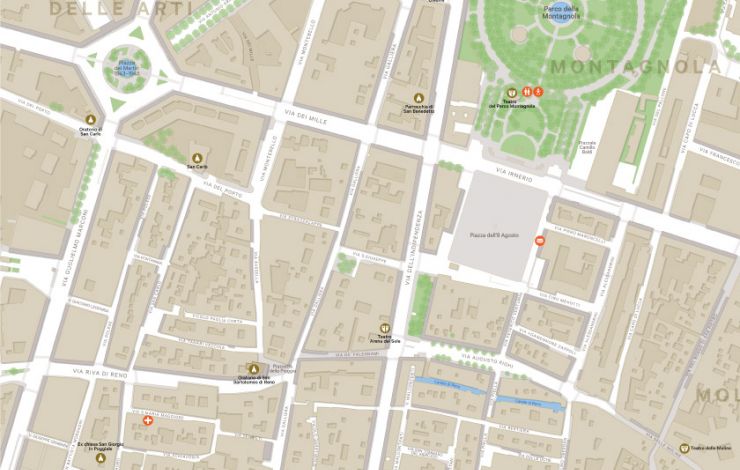
Bologna is a unique city with almost 40 kilometres of porticos (covered walkways) within the historic walled centre which is home to a varied mixture of monuments, landmarks and architecture. The key for any proposed system is to be able to communicate this rich history into products that are of the place but do not compromise the functional effectiveness of the system.

Elements of the strategy included establishing a set of conventions and a hierarchy for naming areas and places. One of the primary outputs of the strategy was the first phase development of a city wide pedestrian map. The wayfinding project is also the first expression of the new city brand.

The project is currently ongoing.

On
Steer group

We are Steer

Yes, you are in the right place. After 40 years, we have changed our name from Steer Davies Gleave to mark our growing international footprint and our expanding portfolio into sectors beyond transport.

Explore our new website to learn more about Steer: who we are, how we work and what our future holds.

Complex challenges.
Powerful solutions. 

Footer menu

  • Sectors
  • People
  • Services
  • About
  • Projects
  • Careers
  • Insights
  • Contact
  • Events
  • Our impact

©2025 Steer      Legal & policies        Cookie settings

Subscribe to our newsletter

  • Facebook
  • Twitter
  • Linkedin
  • Instagram
  • Spotify

Back to top